Research

WP1- Extracting 3D-data from HR imagery

What?

In work package 1, digital surface models and ortho-images will be extracted from very high resolution satellite imagery over an urban area. More specific, height models will be derived from Ikonos imagery, covering a study area of 60 km² and extending from the centre of Istanbul to the urban fringe.
Built-up areas are known as being complex for photogrammetric purposes, mainly because of the steep changes in elevation caused by buildings and urban features. To make surface model extraction more robust and to cope with the specific problems of height displacement, concealed areas and shadow, a tri-stereoscopic based approach is followed. A methodology is developed to improve the radiometry and geometric alignment of the imagery, to optimize the semi-automatical derivation of DSMs and to enhance the quality of the resulting surface model and especially to enhance the rectangular shape of the buildings by applying spatial filters.

Why?

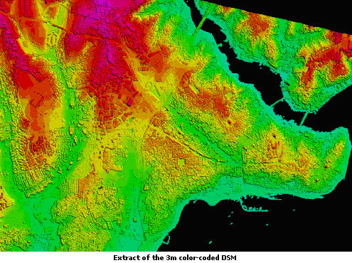
As satellites take images of the earth continuously, they are expected to be a very important and reliable data source to monitor and describe urban areas and its changes. Hereby, detailed information on the third dimension is vital for identification of occluded and shaded areas, to label urban features and to describe urban morphology. Especially in mega-cities as Istanbul a lot of changes will appear in height.
A tri-stereoscopic based approach is followed to derive DSMs. As the stereo case is the minimum case for 3D mapping, the redundancy of an image triplet gives better constraints.
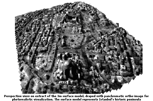
The resulting surface models and ortho-images will be used as an input for the high resolution land-cover mapping of Work package WP2. If the subsequent approach is proved to be successful, it will also increase the flexibility of producing semi-automatic 3D city models from high resolution satellite imagery.

How?

The multiple image dataset consists of an along-track Ikonos stereopair combined with a nearly vertical Ikonos image from more or less the same orbit. The panchromatic imagery has a spatial resolution of 1 m. Processing of the Ikonos triplet is performed with a photogrammetric software package, called SAT-PP. SAT-PP is able to perform image matching on more then two images simultaneously.
To improve the global quality of the surface model and especially to enhance the rectangular shape of the buildings, spatial filtering is applied. More specific, a 7 by 7 median filter is applied on the surface model. The filter not only enhances edges but reduces also noise and outliners.
 More info

Results

The surface model, extracted from the Ikonos triplet, is processed at a grid size of 3 meters. The chosen resolution leads to the best equilibrium between detail and reduction of noise. As illustrated in the figures, the shape of big buildings and free-standing buildings is represented well, while in the very dense urban area small buildings are merged into building blocks. A ground sample distance of 1 m or 1 pixel is chosen for the ortho-image. The geometric accuracy for the DSM extraction, calculated from 22 independent GCP, consists of an overall RMS value of 0.79 m for X residuals, 0.78 m for Y residuals and 2.26 m for Z residuals.


Webmaster
Last modification date = 30-04-2009